28 Beautiful Photographs of the Colorado Trail in Fall
This article is part of a series about bikepacking the Colorado Trail. If you haven't already I'd highly suggest reading the introductory post which briefly describes the Colorado Trail as well as details my experience. Articles in the series are listed below:
- A Basic Guide to Bikepacking The Colorado Trail
- Logistics and Planning Advice for Bikepacking the Colorado Trail
- Gear Recommendations and Packing List for Bikepacking the Colorado Trail
- How Much Time Does it Take to Hike the Colorado Trail?
I hope you enjoy both the articles and the photos that follow. These photos follow a chronological progression of my bikepacking trip on the Colorado Trail from Denver to Durango starting on September 16th, 2016. Enjoy!
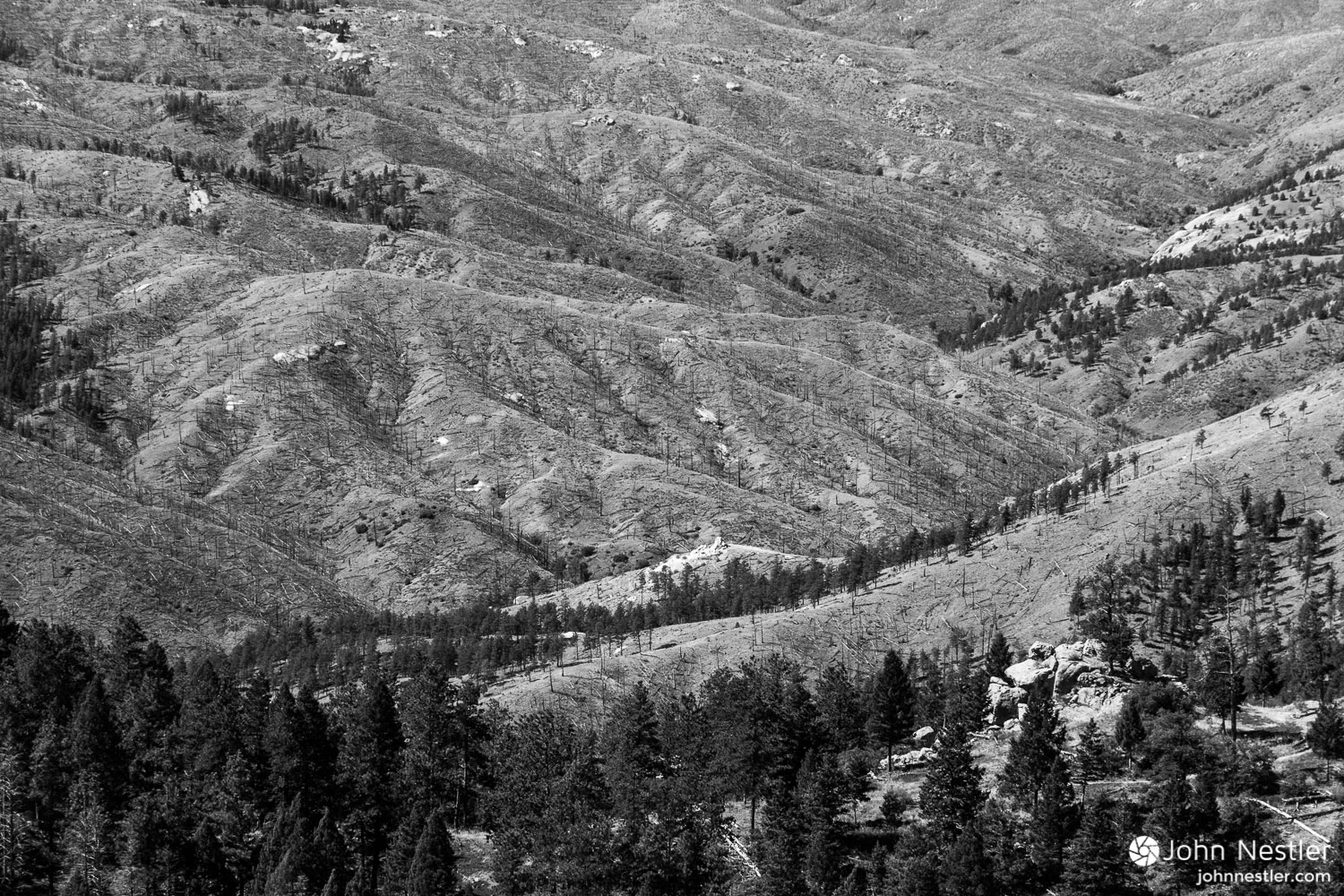
An aerial view of the devastation from the 1996 Buffalo Creek fire. You can clearly see how slowly revegetation takes place in these Ponderosa Pine stands. Shot around Segment 2.
Somewhere past the town of Tarryall, CO during the Lost Creek Wilderness detour. Miles flew by on the paved roads and gorgeous views like this kept me going.
Looking out over South Park, CO toward the Continental Divide while heading towards Kenosha Pass in Segment 5. This was by far the most beautiful section for aspens.
A victory shot at the top of the Tenmile Range overlooking Breckenridge, CO in Segment 7. This was the steepest section of trail, climbing 3,600 feet in 6 miles. I awoke at 4 AM for an alpine push from just below treeline, and made it to the top for sunrise. I'd push on to Leadville later in the day.
A view from the Colorado Trail as it crosses directly across the ski slopes at Copper Mountain in Segment 8. Keep that in mind next time you're there skiing in the winter!
An Abert's squirrel pauses while nibbling away at the cone of a Ponderosa Pine. It slowly removes all the scales from the cone, leaving just the seed. Shot in Segment 8 near Copper Mountain Ski Resort.
Taking in the view from just below Searle Pass after making my way past Copper Mountain in Segment 8. The Tenmile Range can be seen in the top right, and the Colorado Trail extends from the bottom left to the center of the photo.
The stark effects of mining are shown here in Segment 8. Elk Ridge provided this view of the Climax Mine shortly before rain set in as I made my way towards Tennessee Pass and Leadville.
Follow the yellow brick road. Aspen leaves blanket the Colorado Trail as it heads towards Twin Lakes, CO. Shot in Segment 11.
The blazing yellow of Aspen as their prime contrasts beautifully with bluebird skies. Shot near Twin Lakes, CO in Segment 11.
A message was waiting for me when I arrived at a campsite along Little Browns Creek in Segment 14. Stop and smell the flowers - good advice for anyone on the trail. Soak it in!
Enjoying a beautiful bit of riding around treeline where the Colorado Trail intersects the Monarch Crest Trail momentarily in Segment 15. Smooth, flowy trails with bluebird skies made for a memorable day.
A stark reminder that nature is always a cycle of life and death. Here the remains of a calf lay across the trail shortly before reaching Sargents Mesa in Segment 16.
Rocks and roots keep you on your toes as you maneuver a loaded bike down the Colorado Trail. Here I'm enjoying a nice respite from climbing and hiking the bike uphill. Shot on Segment 17.
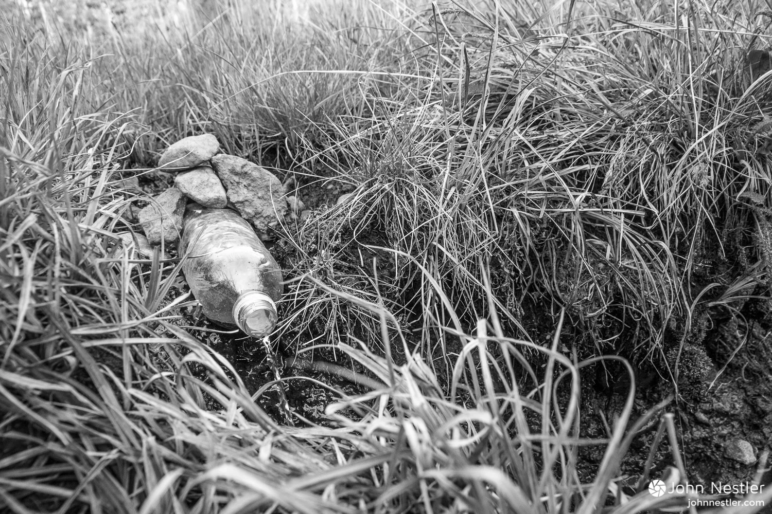
Thank you to the creative hiker who dammed up the trickle of water here and redirected it through a water bottle. I arrived parched at Razor Creek, and found next to nothing in the creek. This meager flow of water made my night. Shot in Segment 17.
The ride along Cebolla Creek just kept getting prettier. Here's a shot near the top with a breathtaking mix of fall colors. Shot on the La Garita Wilderness detour.
Threatening clouds hover above peaks by Lake City, CO. Shot near the end of the La Garita Wilderness detour on the approach to Slumgullion Pass.
Brief bursts of rain turned the exposed earth into tacky mud that clung to the tires and prevented any type of riding. Shot shortly after Spring Creek Pass in Segment 22.
Rain may dampen the day, but chasing rainbows on the Colorado Trail surely brightens the day. Shot on Segment 21 shortly before Jarosa Mesa, looking down towards Spring Creek Pass.
Waking up to a clear, freezing morning as hail from the night before still clings to the tent. A couple hours of sun melted the tent as well as my clothes, making the rest of the day much more comfortable. Shot in the Jarosa Mesa area in Segment 22.
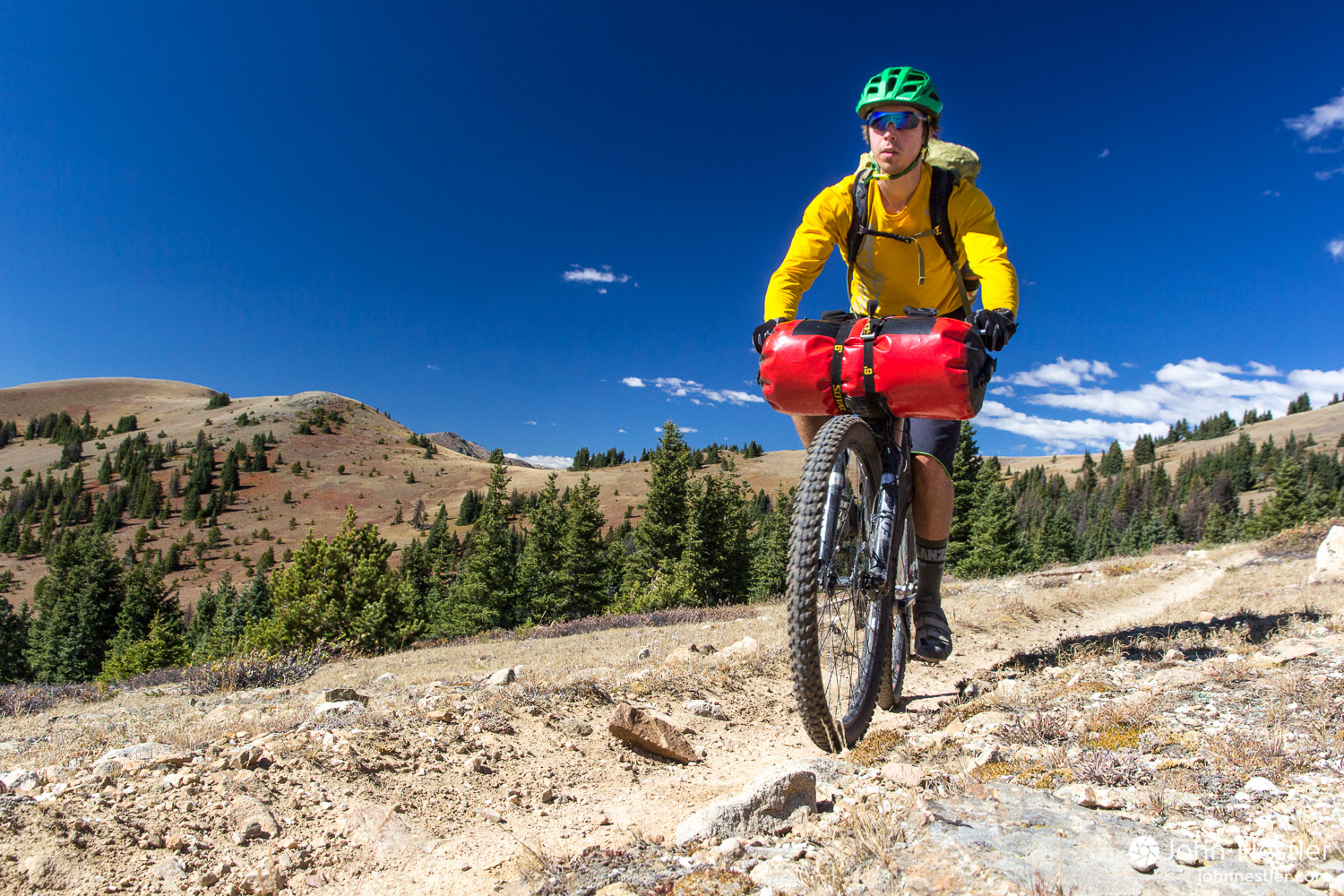
This is Gabriel, the only other bikepacker I met going Denver to Durango while biking the Colorado Trail. This was shot at Carson Saddle, shortly after descending from the high point on the trail at 13,271'. Gabriel had just broken his rear derailleur hanger and was working hard to make the 25 miles to Silverton that night on a crippled bike. I have a feeling it turned into a small epic.
Gabriel, a fellow bikepacker, threads through the landscape on the Colorado Trail by Cataract Lake in Segment 23.
A view of possibly the most beautiful campsite on the whole trip. Few things match the experience of sunset colors and alpine lakes after a long day of riding. Shot by a small lake near Cataract Lake in Segment 23.
Breaking down camp after a chilly night of freezing rain and hail, which left a clear print around the Mega Light tent. Shot near Little Molas Lake on Segment 25 just outside of Silverton, CO.
Clouds and winter weather roll in shortly into Segment 25 after leaving camp at Little Molas Lake. The weather made for a long, wet slog through alternating snow, rain, and gusts of hail.
Staying warm and trucking on in the mixed winter conditions of southwest Colorado. Shot near the pass south of Rolling Mountain in Segment 25.
Warm, sunny conditions near Bolam Pass Road were greeted after enduring snow and wind for most the day on Segment 25.
A gorgeous view of late-season aspen colors leading up snow capped mountains. Shot prior to the Indian Ridge section leading towards Kennebec Trailhead in Segment 27.
Any questions or opinions? I'd love to hear from you, just leave a comment below.
Like this post? Sign up below for an email newsletter from the site. No spam, I promise!


The White Rim has been on my radar as an iconic loop for quite a while now, and it was one of the first big adventures on my list to do after moving to Utah. Unfortunately I moved at the beginning of summer and temperatures were pretty toasty in the Moab area. Luckily I saw a one-day weather window of lows in the 60's and a high of 80 so I decided to go for it.
I started before sunrise at the bottom of the Mineral Bottom switchbacks in order to beat the heat on the strenuous climb up towards State Route 313. The switchbacks are definitely pretty steep and gnarly to drive down but the Prius made it down without issue as the road was in pretty good condition at the time. I started at 3:30 AM, and the climb up the switchbacks actually flew by in just 30 minutes. From there I hit SR 313 in time for a beautiful sunrise and then began the fun of descending the Schafer switchbacks while continually being in awe of the landscape around me.